
Haz una donación
Mapa topográfico Olga
Haga clic en el mapa para ver la altitud.
Haz una donación
Acerca de este mapa
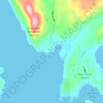
Nombre: Mapa topográfico Olga, altitud, relieve.
Lugar: Olga, San Juan County, Washington, 98279, United States (48.59955 -122.85546 48.63955 -122.81546)
Altitud media: 55 m
Altitud mínima: -2 m
Altitud máxima: 363 m
Haz una donación
Otros mapas topográficos
Haga clic en un mapa para ver su topografía, su altitud y su relieve.
Orcas Island
United States > Washington > San Juan County > Eastsound
Mount Constitution (elevation 2409 feet/734 meters) is the highest point in the San Juan islands. The mountain is part of Moran State Park, the largest public recreation area in the San Juan Islands, and the largest State Park in Washington. Moran State Park encompasses over 5,000 acres (2,000 ha) of woodland…
Altitud media: 59 m
Haz una donación
Haz una donación
Haz una donación
Haz una donación
San Juan Islands National Wildlife Refuge
United States > Washington > San Juan County
Altitud media: 24 m
Orcas Island
United States > Washington > San Juan County > Eastsound
Mount Constitution (elevation 2,409 feet (734 meters) is the highest point in the San Juan islands. The mountain is part of Moran State Park, the largest public recreation area in the San Juan Islands, and the largest State Park in Washington. Moran State Park encompasses over 5,000 acres (2,000 hectares) of…
Altitud media: 59 m
Haz una donación