
Haz una donación
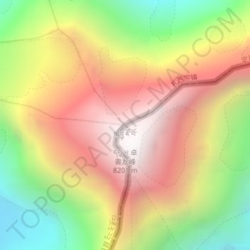
Mapa topográfico Cho Oyu
Haga clic en el mapa para ver la altitud.
Haz una donación
Cho Oyu
Cho Oyu's height was originally measured at 26,750 feet (8,150 m) and at the time of the first ascent it was considered the 7th highest mountain on earth, after Dhaulagiri at 8,167 metres (26,795 ft) (Manaslu, now 8,156 metres (26,759 ft), was also estimated lower at 26,658 feet (8,125 m)). A 1984 estimate of 8,201 metres (26,906 ft) made it move up to sixth place. New measurements made in 1996 by the Government of Nepal Survey Department and the Finnish Meteorological Institute in preparation for the Nepal Topographic Maps put the height at 8,188 m, one remarkably similar to the 26,867 feet (8,189 m) used by Edmund Hillary in his 1955 book High Adventure.
Haz una donación
Acerca de este mapa
Nombre: Mapa topográfico Cho Oyu, altitud, relieve.
Altitud media: 7.339 m
Altitud mínima: 6.425 m
Altitud máxima: 8.172 m
Haz una donación
Otros mapas topográficos
Haga clic en un mapa para ver su topografía, su altitud y su relieve.
Shelkar
China > Tibet > Tingri County
The town lies 7 kilometres (4.3 mi) off the Friendship Highway between Lhatse and Tingri, at an altitude of about 4,300 metres (14,100 ft), at the southern foot of 5,260 metres (17,260 ft) high Gyatso La. It is approximately 60 kilometres (37 mi) north-west of Mount Everest and just over 50 kilometres (31 mi)…
Altitud media: 4.831 m
Haz una donación