
Gracias por apoyar a este sitio ❤️
Haz una donación
Haz una donación
Mapa topográfico Leimakhong
Haga clic en el mapa para ver la altitud.
Gracias por apoyar a este sitio ❤️
Haz una donación
Haz una donación
Acerca de este mapa
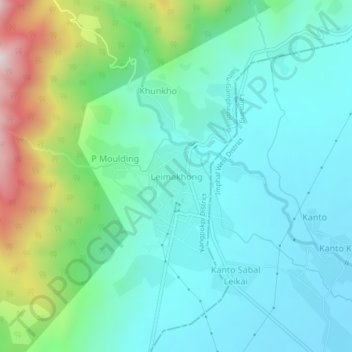
Nombre: Mapa topográfico Leimakhong, altitud, relieve.
Lugar: Leimakhong, Kangpokpi district, Manipur, 795136, India (24.92297 93.81987 24.96297 93.85987)
Altitud media: 967 m
Altitud mínima: 811 m
Altitud máxima: 1.464 m
Gracias por apoyar a este sitio ❤️
Haz una donación
Haz una donación
Otros mapas topográficos
Haga clic en un mapa para ver su topografía, su altitud y su relieve.
Loktak Lake
India > Manipur > Bishnupur > Thanga
At the Ithai barrage outlet of the Lake, the direct catchment area draining into the lake is 980 km2 (380 sq mi) out of which 430 km2 (170 sq mi) is under paddy cultivation, 150 km2 (58 sq mi) under habitation and 400 km2 (150 sq mi) under forest cover. The area of the lake is 236.21 km2 (91.20 sq mi),…
Altitud media: 772 m
Gracias por apoyar a este sitio ❤️
Haz una donación
Haz una donación