
Haz una donación
Mapa topográfico Idria
Haga clic en el mapa para ver la altitud.
Haz una donación
Acerca de este mapa
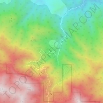
Nombre: Mapa topográfico Idria, altitud, relieve.
Lugar: Idria, San Benito County, California, United States (36.39690 -120.69434 36.43690 -120.65434)
Altitud media: 968 m
Altitud mínima: 570 m
Altitud máxima: 1.415 m
Haz una donación
Otros mapas topográficos
Haga clic en un mapa para ver su topografía, su altitud y su relieve.
Pinnacles National Park
United States > California > San Benito County
Elevation within the boundaries range from 824 to 3,304 feet (251 to 1,007 m) at the peak of North Chalone Peak.
Altitud media: 495 m
Haz una donación
Pinnacles National Park
United States > California > San Benito County
Elevation within the boundaries range from 824 to 3,304 feet (251 to 1,007 m) at the peak of North Chalone Peak.
Altitud media: 495 m
Pinnacles National Park
United States > California > San Benito County
Elevation within the boundaries range from 824 to 3,304 feet (251 to 1,007 m) at the peak of North Chalone Peak.
Altitud media: 495 m