
Haz una donación
Mapa topográfico Paliano
Haga clic en el mapa para ver la altitud.
Haz una donación
Acerca de este mapa
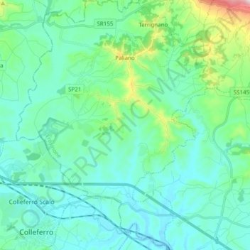
Nombre: Mapa topográfico Paliano, altitud, relieve.
Lugar: Paliano, Frosinone, Lazio, 03018, Italy (41.71895 12.99187 41.83217 13.10868)
Altitud media: 272 m
Altitud mínima: 183 m
Altitud máxima: 703 m
Haz una donación
Otros mapas topográficos
Haga clic en un mapa para ver su topografía, su altitud y su relieve.
Monte Cassino
Italy > Lazio > Frosinone > Cassino
Monte Cassino (today usually spelled Montecassino) is a rocky hill about 130 kilometres (80 mi) southeast of Rome, in the Latin Valley, Italy, 2 kilometres (1+1⁄4 mi) west of Cassino and at an elevation of 520 m (1,710 ft). Site of the Roman town of Casinum, it is widely known for its abbey, the first house…
Altitud media: 231 m