
Gracias por apoyar a este sitio ❤️
Haz una donación
Haz una donación
Mapa topográfico Shasta Lake
Haga clic en el mapa para ver la altitud.
Gracias por apoyar a este sitio ❤️
Haz una donación
Haz una donación
Acerca de este mapa
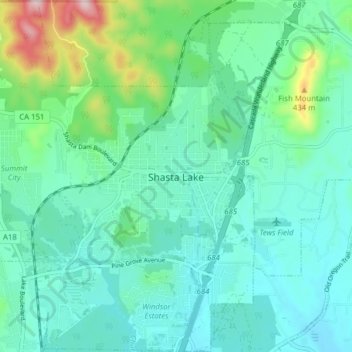
Nombre: Mapa topográfico Shasta Lake, altitud, relieve.
Lugar: Shasta Lake, Shasta County, California, United States (40.65048 -122.41133 40.70976 -122.33699)
Altitud media: 265 m
Altitud mínima: 192 m
Altitud máxima: 554 m
Gracias por apoyar a este sitio ❤️
Haz una donación
Haz una donación
Otros mapas topográficos
Haga clic en un mapa para ver su topografía, su altitud y su relieve.
Redding
United States > California > Shasta County > Redding
The elevation in Redding is 495 feet (151 meters) on average, whereas anywhere to the north, east, or west of downtown ranges between 550 feet (170 m) and 800 feet (240 m) feet. Southern portions range between 400 feet (120 m) and 500 feet (150 m).
Altitud media: 312 m
Gracias por apoyar a este sitio ❤️
Haz una donación
Haz una donación