
Haz una donación
Mapa topográfico Peterborough
Haga clic en el mapa para ver la altitud.
Haz una donación
Peterborough
Peterborough's topography is largely defined by land formations created by the receding Wisconsian glaciers 10,000–15,000 years ago. The South End and Downtown portions of the city sit on what was the bottom of the glacial Lake Peterborough—part of a glacial spillway created when glacial meltwaters from ancient Lake Algonquin (now Lake Huron) travelled south to ancient Lake Iroquois (now Lake Ontario). This area of relatively low and flat relief (approximately 191–200 m (627–656 ft) above sea level) is prone to flooding, exemplified in the major flood that occurred on July 15, 2004. The ground elevation rises to the west, north, and east where a large upland area (the Peterborough Drumlin field) defines the landscape. Much of the land in the north and west ends of the city rises to 230–274 m (755–899 ft) above sea level, with Tower Hill, at 286 m (938 ft) above sea level, being the highest point. Armour Hill, another prominent drumlin located in east city, forms the physical obstacle that the Trent-Severn Waterway ascends by way of the Peterborough Lift Lock. The Oak Ridges Moraine is located approximately 15 km (9.3 mi) south of the city.
Haz una donación
Acerca de este mapa
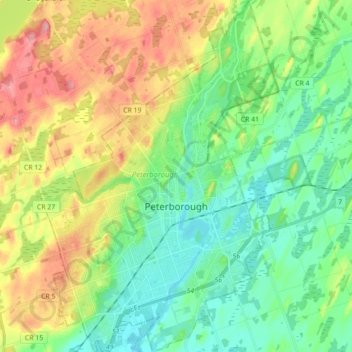
Nombre: Mapa topográfico Peterborough, altitud, relieve.
Lugar: Peterborough, Central Ontario, Ontario, Canada (44.25263 -78.38797 44.37849 -78.26833)
Altitud media: 232 m
Altitud mínima: 186 m
Altitud máxima: 317 m
Haz una donación
Otros mapas topográficos
Haga clic en un mapa para ver su topografía, su altitud y su relieve.
Toronto
Despite its deep ravines, Toronto is not remarkably hilly, but its elevation does increase steadily away from the lake. Elevation differences range from 76.5 metres (251 ft) above sea level at the Lake Ontario shore to 209 m (686 ft) ASL near the York University grounds in the city's north end at the…
Altitud media: 113 m
London
Canada > Ontario > London > London
London has a humid continental climate (Köppen Dfb), though due to its downwind location relative to Lake Huron and elevation changes across the city, it is virtually on the Dfa/Dfb (hot summer) boundary favouring the former climate zone to the southwest of the confluence of the South and North Thames Rivers,…
Altitud media: 268 m
Haz una donación
Guelph
This region of Ontario has cold winters and warm, humid summers, falling into the Köppen climate classification Dfb zone, with moderately high rainfall and snowfall. It is generally a couple of degrees cooler than lower elevation regions on the Great Lakes shorelines, especially so in winter, the exception…
Altitud media: 344 m
Haz una donación
Dundas
Canada > Ontario > Hamilton > Dundas
Dundas /ˈdʌnˌdæs/ is a community and former town in Hamilton, Ontario, Canada. It is nicknamed the Valley Town because of its topographical location at the bottom of the Niagara Escarpment on the western edge of Lake Ontario. The population has been stable for decades at about twenty thousand, largely…
Altitud media: 171 m
Haz una donación
Peterborough
Canada > Ontario > Peterborough
Peterborough's topography is largely defined by land formations created by the receding Wisconsian glaciers 10,000–15,000 years ago. The South End and Downtown portions of the City sit on what was the bottom of the glacial Lake Peterborough—part of a glacial spillway created when glacial meltwaters from…
Altitud media: 235 m
Haz una donación
Whitefish Lake
Canada > Ontario > Thunder Bay District > Unorganized Thunder Bay District
Altitud media: 472 m
Haz una donación
Painkiller Lake
Canada > Ontario > Cochrane District > Black River-Matheson Township
Altitud media: 302 m
Haz una donación
Haz una donación
Haz una donación
Haz una donación
Haz una donación
Haz una donación
Haz una donación
Haz una donación
Haz una donación
London
London has a humid continental climate (Köppen Dfb), though due to its downwind location relative to Lake Huron and elevation changes across the city, it is virtually on the Dfa/Dfb (hot summer) boundary favouring the former climate zone to the southwest of the confluence of the South and North Thames Rivers,…
Altitud media: 269 m
Haz una donación
Haz una donación
Haz una donación
Haz una donación
Haz una donación
Manitouwabing Lake
Canada > Ontario > Parry Sound District > McKellar Township > McKellar
Altitud media: 249 m
Haz una donación
Haz una donación
Haz una donación
Haz una donación
Haz una donación
Haz una donación