
Haz una donación
Mapa topográfico Tecolote Peak
Haga clic en el mapa para ver la altitud.
Haz una donación
Acerca de este mapa
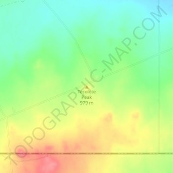
Nombre: Mapa topográfico Tecolote Peak, altitud, relieve.
Lugar: Tecolote Peak, Eddy County, New Mexico, United States (32.01035 -104.16221 32.01045 -104.16211)
Altitud media: 968 m
Altitud mínima: 933 m
Altitud máxima: 1.012 m
Haz una donación
Otros mapas topográficos
Haga clic en un mapa para ver su topografía, su altitud y su relieve.
Artesia
United States > New Mexico > Eddy County
Artesia is located in northern Eddy County at 32°50′34″N 104°24′44″W / 32.84278°N 104.41222°W / 32.84278; -104.41222 (32.842744, -104.412315), at an elevation of 3,380 feet (1,030 m). US 82 leads east 64 miles (103 km) to Lovington and west 110 miles (180 km) to Alamogordo, while US 285…
Altitud media: 1.037 m
Carlsbad
United States > New Mexico > Eddy County
Carlsbad is located near the center of Eddy County at 32°24′43″N 104°14′11″W / 32.41194°N 104.23639°W / 32.41194; -104.23639 (32.407577, -104.245167) at an elevation of 3,295 feet (1,004 m). Carlsbad is situated in the northern reaches of the Chihuahuan Desert ecoregion, in the lower Pecos…
Altitud media: 983 m
Haz una donación
Carlsbad
United States > New Mexico > Eddy County
Carlsbad is located near the center of Eddy County at 32°24′43″N 104°14′11″W / 32.41194°N 104.23639°W / 32.41194; -104.23639 (32.407577, -104.245167) at an elevation of 3,295 feet (1,004 m). Carlsbad is situated in the northern reaches of the Chihuahuan Desert ecoregion, in the lower Pecos…
Altitud media: 983 m