
Gracias por apoyar a este sitio ❤️
Haz una donación
Haz una donación
Mapa topográfico Kala Patthar
Haga clic en el mapa para ver la altitud.
Gracias por apoyar a este sitio ❤️
Haz una donación
Haz una donación
Kala Patthar
The views of Everest, Nuptse and Changtse are spectacular from Kala Patthar and there are glimpses of the northern flank and summit of Lhotse. The world's highest webcam, Mount Everest webcam, was located here. Kala Patthar is considered the highest altitude most will reach without a climbing permit, which must be obtained in Kathmandu, at the Nepal Mountaineering Association.
Gracias por apoyar a este sitio ❤️
Haz una donación
Haz una donación
Acerca de este mapa
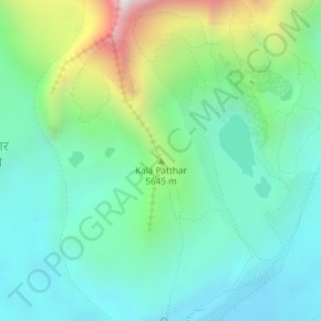
Nombre: Mapa topográfico Kala Patthar, altitud, relieve.
Altitud media: 5.434 m
Altitud mínima: 5.133 m
Altitud máxima: 6.285 m
Gracias por apoyar a este sitio ❤️
Haz una donación
Haz una donación
Otros mapas topográficos
Haga clic en un mapa para ver su topografía, su altitud y su relieve.