
Haz una donación
Mapa topográfico Roustika
Haga clic en el mapa para ver la altitud.
Haz una donación
Roustika
Roustika is located twenty kilometers southwest of Rethymno at an altitude of 290 m at the foot of the hill Ambelos. Roustika existed before the conquest of Crete by the Venetians. The name could originate from the Arabic word Roustak (which means: village) and it is believed that the Venetians adapted the name to their language as Roustika. Others believe it originates from the Latin word rustic (=rural).
Haz una donación
Acerca de este mapa
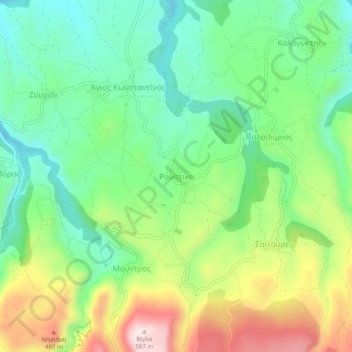
Nombre: Mapa topográfico Roustika, altitud, relieve.
Altitud media: 297 m
Altitud mínima: 147 m
Altitud máxima: 561 m
Haz una donación
Otros mapas topográficos
Haga clic en un mapa para ver su topografía, su altitud y su relieve.
Municipality of Agios Vasileios
Greece > Region of Crete > Rethymno Regional Unit
Altitud media: 247 m
Myli Gorge
Greece > Region of Crete > Rethymno Regional Unit > Xiro Chorio > Myli
Altitud media: 198 m
Haz una donación