
Haz una donación
Mapa topográfico Hooker Hills
Haga clic en el mapa para ver la altitud.
Haz una donación
Acerca de este mapa
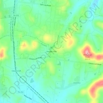
Nombre: Mapa topográfico Hooker Hills, altitud, relieve.
Altitud media: 250 m
Altitud mínima: 209 m
Altitud máxima: 346 m
Haz una donación
Otros mapas topográficos
Haga clic en un mapa para ver su topografía, su altitud y su relieve.
Fairview
United States > Tennessee > Williamson County
Fairview was incorporated on July 28, 1959, under the Uniform City Manager-Commission Charter as set out in the Tennessee Code Annotated. Fairview city limits are located about one mile (1.6 km) southwest from the Nashville-Davidson County line and has two interstates passing through it (I-40 & I-840). With an…
Altitud media: 233 m
Haz una donación
Haz una donación
Fairview
United States > Tennessee > Williamson County
Fairview was incorporated on July 28, 1959, under the Uniform City Manager-Commission Charter as set out in the Tennessee Code Annotated. Fairview city limits are located about one mile (1.6 km) southwest from the Nashville-Davidson County line and has two interstates passing through it (I-40 & I-840). With an…
Altitud media: 233 m