
Mapa topográfico Beachley
Haga clic en el mapa para ver la altitud.
Acerca de este mapa
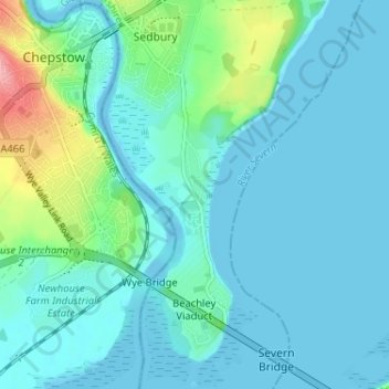
Nombre: Mapa topográfico Beachley, altitud, relieve.
Altitud media: 13 m
Altitud mínima: -13 m
Altitud máxima: 103 m
Otros mapas topográficos
Haga clic en un mapa para ver su topografía, su altitud y su relieve.
Cinderford Skate Park
United Kingdom > England > Gloucestershire > Forest of Dean District > Cinderford
Altitud media: 198 m