
Gracias por apoyar a este sitio ❤️
Haz una donación
Haz una donación
Mapa topográfico Cardwell Mountain
Haga clic en el mapa para ver la altitud.
Gracias por apoyar a este sitio ❤️
Haz una donación
Haz una donación
Acerca de este mapa
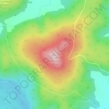
Nombre: Mapa topográfico Cardwell Mountain, altitud, relieve.
Altitud media: 386 m
Altitud mínima: 263 m
Altitud máxima: 571 m
Gracias por apoyar a este sitio ❤️
Haz una donación
Haz una donación
Otros mapas topográficos
Haga clic en un mapa para ver su topografía, su altitud y su relieve.
McMinnville
United States > Tennessee > Warren County
According to the United States Census Bureau, the city has a total area of 10.0 square miles (26 km2), all land. McMinnville lies at an elevation of 968 feet (295 m), as it sits along the Eastern Highland Rim near the base of the Cumberland Plateau. The city is drained primarily by the Barren Fork, a tributary…
Altitud media: 302 m