
Haz una donación
Mapa topográfico Peshawar
Haga clic en el mapa para ver la altitud.
Haz una donación
Acerca de este mapa
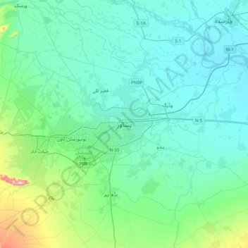
Nombre: Mapa topográfico Peshawar, altitud, relieve.
Altitud media: 359 m
Altitud mínima: 289 m
Altitud máxima: 766 m
Haz una donación
Otros mapas topográficos
Haga clic en un mapa para ver su topografía, su altitud y su relieve.
Kabal Tehsil
Pakistan > Khyber Pakhtunkhwa > Swat District
Kabal Town is located at 34°47′N 72°17′E / 34.783°N 72.283°E / 34.783; 72.283 at an altitude of 845 metres (2,772 ft).
Altitud media: 1.477 m
Tarbela Dam
Pakistan > Khyber Pakhtunkhwa > Haripur District
Tarbela Reservoir is 80.5 kilometres (50.0 mi) long, with a surface area of 250 square kilometres (97 sq mi). The reservoir initially stored 11,600,000 acre-feet (14.3 km3) of water, with a live storage of 9,700,000 acre-feet (12.0 km3), though this figure has been reduced over the subsequent 35 years of…
Altitud media: 451 m
Mastuj Tehsil
Pakistan > Khyber Pakhtunkhwa > Chitrāl District
Mastuj (Urdu: مستوج) is a tehsil of Upper Chitral District in Khyber-Pakhtunkhwa province of Pakistan; Mastuj is the principal settlement. It is located at 36°17'0N 72°31'0E with an altitude of 2359 metres (7742 feet). There are ruins of old fort built originally in 18th century and reconstructed several times.
Altitud media: 4.143 m
Chitrāl District
Chitral is connected to the rest of Pakistan by two major road routes, the Lowari Pass (el. 10,230 ft.) from Dir and Shandur Top (elevation 12,200 ft.) from Gilgit. Both routes used to be closed in winter, but circa 2017 the highway Lowari Tunnel under the Lowari Pass opened to vehicular traffic for at least…
Altitud media: 3.729 m
Haz una donación