
Haz una donación
Mapa topográfico Mount Hayfield
Haga clic en el mapa para ver la altitud.
Haz una donación
Acerca de este mapa
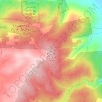
Nombre: Mapa topográfico Mount Hayfield, altitud, relieve.
Altitud media: 278 m
Altitud mínima: 113 m
Altitud máxima: 364 m
Haz una donación
Otros mapas topográficos
Haga clic en un mapa para ver su topografía, su altitud y su relieve.
Inman Valley
Australia > South Australia > The District Council of Yankalilla
In the valley is Selwyn Rock (35°29′47″S 138°30′45″E / 35.4965°S 138.5124°E / -35.4965; 138.5124) a glaciated pavement in the bed of the Inman River. It was first described in 1859 by, and later named for, A.R.C. Selwyn,[17] who was Victorian Government geologist at the time. Glacial…
Altitud media: 212 m
Deep Creek National Park
Australia > South Australia > The District Council of Yankalilla
Altitud media: 183 m
Haz una donación
Myponga River
Australia > South Australia > The District Council of Yankalilla > Myponga > Myponga Beach
Altitud media: 138 m
Haz una donación
Kalumunda Forest Reserve
Australia > South Australia > The District Council of Yankalilla
Altitud media: 265 m
Haz una donación
Haz una donación
Inman Valley
Australia > South Australia > The District Council of Yankalilla
In the valley is Selwyn Rock (35°29′47″S 138°30′45″E / 35.4965°S 138.5124°E / -35.4965; 138.5124) a glaciated pavement in the bed of the Inman River. It was first described in 1859 by, and later named for, A.R.C. Selwyn, who was Victorian Government geologist at the time. Glacial grooves…
Altitud media: 212 m