
Haz una donación
Mapa topográfico Hyattsville
Haga clic en el mapa para ver la altitud.
Haz una donación
Hyattsville
Downtown Hyattsville underwent revitalization in the early 2000s with the development of Arts District Hyattsville, part of the Gateway Arts District, a private project which includes townhomes, live-work units, and retail space. The master developer of the 25-acre neighborhood was Bethesda-based EYA, and was constructed by EYA, PulteGroup, StreetSense, and Bozzuto Group. A Busboys and Poets restaurant opened in July 2011; other retail offerings include Yes! Organic Market, Elevation Burger, Chipotle Mexican Grill, Spice 6 Modern Indian, and Tara Thai. In the winter of 2015, a traveling exhibition platform Visual Collaborative collaborated with the Arts District Hyattsville Master Association, utilizing the Lustine Center to host a group exhibition themed Vanity.
Haz una donación
Acerca de este mapa
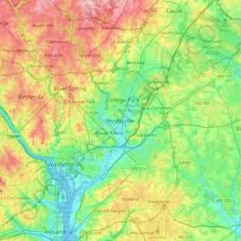
Nombre: Mapa topográfico Hyattsville, altitud, relieve.
Altitud media: 61 m
Altitud mínima: -3 m
Altitud máxima: 165 m
Haz una donación
Otros mapas topográficos
Haga clic en un mapa para ver su topografía, su altitud y su relieve.
University Park
United States > Maryland > Prince George's County > University Park
University Park was developed on land owned by the Deakins family since the mid-1700s. The house known as Deakins Hall or Bloomfield was constructed on the land in the 1820s or 1830s. It is located at 6404 Queens Chapel Road. The farm was purchased by the University Park Company in 1923. The extension of water…
Altitud media: 29 m
Haz una donación
Haz una donación
Rosaryville State Park
United States > Maryland > Prince George's County > Upper Marlboro
Altitud media: 59 m
Haz una donación
Haz una donación
Mount Rainier Community Food Forest
United States > Maryland > Prince George's County > Mount Rainier
Altitud media: 23 m