
Haz una donación
Mapa topográfico Šmrika
Haga clic en el mapa para ver la altitud.
Haz una donación
Acerca de este mapa
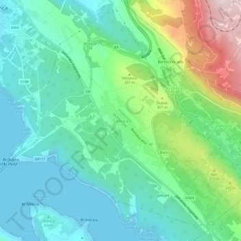
Nombre: Mapa topográfico Šmrika, altitud, relieve.
Altitud media: 165 m
Altitud mínima: 0 m
Altitud máxima: 620 m
Haz una donación
Otros mapas topográficos
Haga clic en un mapa para ver su topografía, su altitud y su relieve.
Krk
Croatia > Primorje-Gorski Kotar County
A Eurasian griffon vulture colony lives in protected in an area called Kuntrep on Krk., There they breed at low elevations, with some nests at 10 m (33 ft). Therefore, contact with people is common.
Altitud media: 95 m
Mali Lošinj
Croatia > Primorje-Gorski Kotar County
Since records began in 1961, the highest temperature recorded at the local weather station at an elevation of 53 metres (174 ft) was 39.0 °C (102.2 °F), on 6 August 2017. From 1981 to 2011, the highest temperature recorded at the Čikat weather station was 36.6 °C (97.9 °F), on 2 August 1998. The coldest…
Altitud media: 9 m
Haz una donación
Haz una donación
Begovo Razdolje
Croatia > Primorje-Gorski Kotar County
Begovo Razdolje (Croatian pronunciation: [bɛ̂ɡɔʋɔ rǎːzdɔːʎɛ]) is a village in Mrkopalj municipality, Primorje-Gorski Kotar County, in western Croatia. At 1,060 m (3,478 ft), it is the settlement with the highest elevation in Croatia.
Altitud media: 1.072 m
Haz una donación
Haz una donación
Haz una donación
Lošinj
Croatia > Primorje-Gorski Kotar County > Veli Lošinj
Lošinj is part of the Cres-Lošinj archipelago. The Cres-Lošinj archipelago includes the two major islands Cres and Lošinj, some minor islands Unije, Ilovik, Susak, Vele Srakane, Male Srakane and a number of uninhabited small islets and outcrops. Cres is the largest by area, followed by Lošinj. Cres and…
Altitud media: 14 m
Haz una donación
Susak
Croatia > Primorje-Gorski Kotar County > Susak
Located in the Kvarner Bay and southeast of the Istrian peninsula, the Croatian island of Susak is 7.4 kilometers (4.6 mi; 4.0 nmi) southwest from the island of Lošinj, 10 kilometers (6.2 mi; 5.4 nmi) south of the island of Unije, and 120 kilometers (75 mi; 65 nmi) east of the Italian coast. Susak is about 3…
Altitud media: 13 m
Haz una donación
Grad Rijeka
Croatia > Primorje-Gorski Kotar County
Since records began in 1948, the highest temperature recorded at the local weather station at an elevation of 120 metres (390 ft) was 40.0 °C (104.0 °F), on 19 July 2007. The coldest temperature was −12.8 °C (9.0 °F), on 10 February 1956.
Altitud media: 209 m
Haz una donación
Haz una donación
Haz una donación
Općina Mrkopalj
Croatia > Primorje-Gorski Kotar County
A weather station exists there at an elevation of 825 metres (2,707 ft), although under a shelter that compromises the applicability to surroundings. The minimum recorded temperature for the winter of 2024–2025 was −16.2 °C (2.8 °F), on February 20.
Altitud media: 1.010 m
Haz una donación
Haz una donación
Haz una donación
Krk
Croatia > Primorje-Gorski Kotar County
The island forms part of the Kvarner Islands Important Bird Area (IBA), designated as such by BirdLife International because it supports significant numbers of many bird species, including breeding populations of several birds of prey. A Eurasian griffon vulture colony lives in a protected area called Kuntrep.…
Altitud media: 95 m