
Gracias por apoyar a este sitio ❤️
Haz una donación
Haz una donación
Mapa topográfico Manassas Gap
Haga clic en el mapa para ver la altitud.
Gracias por apoyar a este sitio ❤️
Haz una donación
Haz una donación
Manassas Gap
Manassas Gap is a wind gap of the Blue Ridge Mountains on the border of Fauquier County and Warren County in Virginia. At an elevation of 887 feet above sea level, it is the lowest crossing of the Blue Ridge Mountains in the state. "The origins of the name "Manassas" are undocumented."
Gracias por apoyar a este sitio ❤️
Haz una donación
Haz una donación
Acerca de este mapa
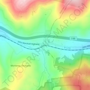
Nombre: Mapa topográfico Manassas Gap, altitud, relieve.
Altitud media: 349 m
Altitud mínima: 248 m
Altitud máxima: 498 m
Gracias por apoyar a este sitio ❤️
Haz una donación
Haz una donación
Otros mapas topográficos
Haga clic en un mapa para ver su topografía, su altitud y su relieve.
Gracias por apoyar a este sitio ❤️
Haz una donación
Haz una donación
Gracias por apoyar a este sitio ❤️
Haz una donación
Haz una donación