
Haz una donación
Mapa topográfico Pomps
Haga clic en el mapa para ver la altitud.
Haz una donación
Acerca de este mapa
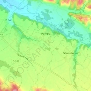
Nombre: Mapa topográfico Pomps, altitud, relieve.
Altitud media: 127 m
Altitud mínima: 85 m
Altitud máxima: 198 m
Haz una donación
Otros mapas topográficos
Haga clic en un mapa para ver su topografía, su altitud y su relieve.
Col de la Pierre Saint-Martin
France > Nouvelle-Aquitaine > Pyrénées-Atlantiques > Arette
Col de la Pierre Saint-Martin (elevation 1,766 m (5,794 ft)) is a mountain pass on the France-Spain border in the western Pyrenees in the department of Pyrénées-Atlantiques (France) and Navarra (Spain). The climb from the Spanish side was used in the 2007 Tour de France.
Altitud media: 1.695 m
Alhahiri
France > Nouvelle-Aquitaine > Pyrénées-Atlantiques > Saint-Martin-d'Arrossa
Altitud media: 244 m
Haz una donación
Haz una donación
Haz una donación
Ibarrun
France > Nouvelle-Aquitaine > Pyrénées-Atlantiques > Saint-Pée-sur-Nivelle
Altitud media: 68 m