
Haz una donación
Mapa topográfico Klek
Haga clic en el mapa para ver la altitud.
Haz una donación
Acerca de este mapa
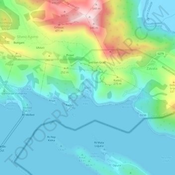
Nombre: Mapa topográfico Klek, altitud, relieve.
Lugar: Klek, Općina Slivno, Dubrovnik-Neretva County, 20356, Croatia (42.92559 17.54331 42.96559 17.58331)
Altitud media: 131 m
Altitud mínima: -4 m
Altitud máxima: 552 m
Haz una donación
Otros mapas topográficos
Haga clic en un mapa para ver su topografía, su altitud y su relieve.
Haz una donación
Dubrovnik
Croatia > Dubrovnik-Neretva County
Since records began in 1961, the highest temperature recorded at the local weather station at an elevation of 52 metres (171 ft) was 38.9 °C (102.0 °F), on 13 August 2025. The coldest temperature was −7.0 °C (19.4 °F), on 14 January 1968.
Altitud media: 297 m
Lastovo
Croatia > Dubrovnik-Neretva County > Općina Lastovo
Since records began in 1949, the highest temperature recorded at the local weather station at an elevation of 186 metres (610 ft) was 38.3 °C (100.9 °F), on 3 August 1998. The coldest temperature was −6.8 °C (19.8 °F), on 23 January 1963.
Altitud media: 35 m
Haz una donación
Haz una donación
Grad Ploče
Croatia > Dubrovnik-Neretva County
Ploče at an elevation of 2 metres (6.6 ft) is the location of Croatia's high temperature record, measured at 42.8 °C (109.0 °F) on 4 and 5 August 1981. Records for the Ploče weather station began in 1975. The coldest temperature was −8.9 °C (16.0 °F), on 13 January 1985.
Altitud media: 140 m
Haz una donación
Haz una donación
Haz una donación
Haz una donación
Haz una donación
Haz una donación
Haz una donación