
Haz una donación
Mapa topográfico Amai Manabilang
Haga clic en el mapa para ver la altitud.
Haz una donación
Amai Manabilang
Mountain ranges, hills, plateaus, and flatland characterize the topography of the barangay. It has a vast agricultural land suited for crops like rice, corn, carrots, sugar cane. Its hydrological features comprise rivers like the Maridugao and Sumogot, streams, swamps, creeks and springs.
Haz una donación
Acerca de este mapa
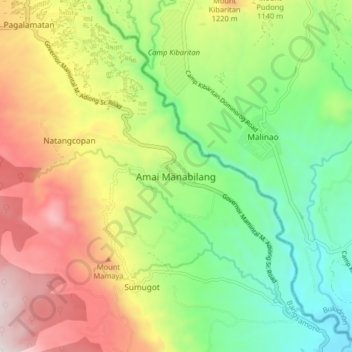
Nombre: Mapa topográfico Amai Manabilang, altitud, relieve.
Lugar: Amai Manabilang, Lanao del Sur, Bangsamoro, 9320, Philippines (7.74546 124.64216 7.82546 124.72216)
Altitud media: 967 m
Altitud mínima: 519 m
Altitud máxima: 1.600 m
Haz una donación
Otros mapas topográficos
Haga clic en un mapa para ver su topografía, su altitud y su relieve.
Marawi City
Marawi is located upon the shores of Lake Lanao. It is primarily inhabited by the Maranao people. The city is also called the "Summer Capital of the South" due to its higher elevation and cooler climate, a nickname it shares with Malaybalay.
Altitud media: 707 m
Lake Lanao
The lake has great hydroelectric potential due to its 700 meter elevation, and as such, in 1950, the Philippines National Power Corporation (NAPOCOR) began the construction of a series of hydroelectric plants titled Agus I – Agus VII along the Agus River system, which generates 70% of the electricity used by…
Altitud media: 787 m
Haz una donación
Marawi City
Marawi is located upon the shores of Lake Lanao. It is primarily inhabited by the Maranao people. The city is also called the "Summer Capital of the South" due to its higher elevation and cooler climate, a nickname it shares with Malaybalay.
Altitud media: 707 m
Marawi
Marawi is located upon the shores of Lake Lanao. It is primarily inhabited by the Maranao people. The city is also called the "Summer Capital of the South" due to its higher elevation and cooler climate, a nickname it shares with Malaybalay.
Altitud media: 708 m
Haz una donación
Marawi
Marawi is located upon the shores of Lake Lanao. It is primarily inhabited by the Maranao people. The city is also called the "Summer Capital of the South" due to its higher elevation and cooler climate, a nickname it shares with Malaybalay.
Altitud media: 708 m
Marawi
Marawi is located upon the shores of Lake Lanao. It is primarily inhabited by the Maranao people. The city is also called the "Summer Capital of the South" due to its higher elevation and cooler climate, a nickname it shares with Malaybalay.
Altitud media: 708 m
Marawi City
Marawi is located upon the shores of Lake Lanao. It is primarily inhabited by the Maranao people. The city is also called the "Summer Capital of the South" due to its higher elevation and cooler climate, a nickname it shares with Malaybalay.
Altitud media: 707 m
Haz una donación