
Haz una donación
Mapa topográfico Hendersonville
Haga clic en el mapa para ver la altitud.
Haz una donación
Hendersonville
Hendersonville features a varied topography that enhances its appeal as a lakeside community. The area is predominantly characterized by gentle rolling hills and valleys that rise gradually from the shoreline of Old Hickory Lake, which itself covers approximately 22,000 acres. The elevation in Hendersonville typically ranges from about 500 to 800 feet above sea level, with certain higher points providing panoramic views of the surrounding landscape. This combination of hills and lakefront not only creates a picturesque environment but also supports diverse ecosystems and recreational opportunities, making it a desirable location for both residents and visitors.
Haz una donación
Acerca de este mapa
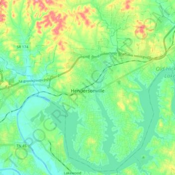
Nombre: Mapa topográfico Hendersonville, altitud, relieve.
Altitud media: 157 m
Altitud mínima: 118 m
Altitud máxima: 257 m
Haz una donación
Otros mapas topográficos
Haga clic en un mapa para ver su topografía, su altitud y su relieve.
Haz una donación
Curtiswood
United States > Tennessee > Sumner County > Hendersonville > Curtiswood
Altitud media: 144 m