
Haz una donación
Mapa topográfico Olympic National Park
Haga clic en el mapa para ver la altitud.
Haz una donación
Olympic National Park
Views of the Olympic National Park can be seen from the Hurricane Ridge viewpoint. The road leading west from the Hurricane Ridge visitor center has several picnic areas and trailheads. A paved trail called the Hurricane Hill trail is about 1.6 miles (2.6 km) long each way, with an elevation gain of about 700 feet (210 m). It is not uncommon to find snow on the trails even as late as July. Several other dirt trails of varying distances and difficulty levels branch off of the Hurricane hill trail. The picnic areas are open only in the summer and have restrooms, water, and paved access to picnic tables.
Haz una donación
Acerca de este mapa
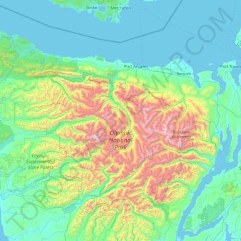
Nombre: Mapa topográfico Olympic National Park, altitud, relieve.
Lugar: Olympic National Park, Washington, United States (47.46977 -124.74259 48.27526 -123.12402)
Altitud media: 412 m
Altitud mínima: -3 m
Altitud máxima: 2.367 m
Haz una donación
Otros mapas topográficos
Haga clic en un mapa para ver su topografía, su altitud y su relieve.
Preston
United States > Washington > King County
Preston is a historic mill town on the northeast edge of the large Tiger Mountain State Forest, along Interstate 90. Preston, elevation 430 ft (130 m), is located within commuting distance of Seattle and Bellevue.
Altitud media: 270 m
Haz una donación
Mount Si
United States > Washington > King County
The peak can be accessed by two trails. The Old Mount Si trail is accessed by the Little Si parking lot and the Boulder Garden Loop. It is 0.6 miles (0.97 km) shorter, 270 feet (82 m) steeper in elevation gain, and less crowded than the main trail. The Mount Si trail is accessed by the Mount Si parking lot.
Altitud media: 793 m
Stevens Pass
United States > Washington > King County
Stevens Pass (elevation 4,061 ft (1,238 m)) is a mountain pass through the Cascade Mountains located at the border of King County and Chelan County in Washington, United States. U.S. Route 2 travels over the pass, reaching a maximum elevation of 4,061 feet (1,238 m). The Pacific Crest Trail crosses the highway…
Altitud media: 1.387 m
Haz una donación
Haz una donación
Haz una donación
Haz una donación
Mount Saint Helens
United States > Washington > Skamania County
The Mount St. Helens major eruption of May 18, 1980 remains the deadliest and most economically destructive volcanic event in U.S. history. Fifty-seven people were killed; 200 homes, 47 bridges, 15 miles (24 km) of railways, and 185 miles (298 km) of highway were destroyed. A massive debris avalanche,…
Altitud media: 2.096 m
Mount Rainier
United States > Washington > Pierce County
Mount Rainier (/reɪˈnɪər/), indigenously known as Tahoma, Tacoma, Tacobet, or təqʷubəʔ, is a large active stratovolcano in the Cascade Range of the Pacific Northwest, located in Mount Rainier National Park about 59 miles (95 km) south-southeast of Seattle. With a summit elevation of 14,411 ft (4,392…
Altitud media: 3.911 m
Haz una donación
Mica Peak
United States > Washington > Spokane County
Mica Peak is the name of two separate mountain summits in the United States located approximately 5.49 miles (9 km) apart; one in Spokane County, Washington and the other in Kootenai County, Idaho. The two peaks are located along the same ridge, which separates the Spokane Valley and Rathdrum Prairie from the…
Altitud media: 1.311 m
Haz una donación
Haz una donación
Haz una donación
Haz una donación
Haz una donación
Mount Ellinor
United States > Washington > Mason County
Mount Ellinor is a peak in the Olympic Mountains of Washington, United States. It is located in an area designated as the Mount Skokomish Wilderness. The mountain is a popular day hike in the summer months; the summit is reachable via a steep-but-brief 3.3-mile (5.3 km) trail which gains about 3,200 feet (980…
Altitud media: 1.334 m
Observatory Hill State Park
United States > Washington > Klickitat County > Goldendale
Altitud media: 540 m
Haz una donación
Mount Adams
United States > Washington > Yakima County
Adams is one of the long-lived volcanoes in the Cascade Range, with minor activity beginning 900,000 years ago and major cone building activity beginning 520,000 years ago. The whole mountain has been completely eroded by glaciers to an elevation of 8,200 feet (2,500 m) twice during its lifetime. The current…
Altitud media: 3.235 m
Haz una donación
Skyline Home Owners Association
United States > Washington > Skagit County > Anacortes
Altitud media: 14 m
Haz una donación
Haz una donación
Sahale Mountain
United States > Washington > Skagit County
The North Cascades features some of the most rugged topography in the Cascade Range with craggy peaks and ridges, deep glacial valleys, and granite spires. Geological events occurring many years ago created the diverse topography and drastic elevation changes over the Cascade Range leading to various climate…
Altitud media: 2.132 m
Haz una donación
Haz una donación
Haz una donación
Haz una donación
Haz una donación
Lake River
United States > Washington > Clark County > Ridgefield
Lake River, a "slow, flat slough of the Columbia River", loses only 1 foot (30 cm) in elevation over its entire 11-mile (18 km) course. It flows north, roughly parallel to the Columbia until curving slightly northwest to join it. At times, tidal fluctuations and high flows along the Columbia cause Lake River…
Altitud media: 35 m
Haz una donación
Haz una donación
Mount Olympus
United States > Washington > Jefferson County
With notable local relief, Mount Olympus ascends over 2,100 m (6,900 ft) from the 293 m (961 ft) elevation confluence of the Hoh River with Glacier Creek in only 8.8 km (5.5 mi). Mount Olympus has 2,386 m (7,828 ft) of prominence, ranking 5th in the state of Washington.
Altitud media: 1.934 m
Cathedral Rock
United States > Washington > Kittitas County
Cathedral Rock is an intrusive andesite volcanic complex. The Alpine Lakes Wilderness features some of the most rugged topography in the Cascade Range with craggy peaks and ridges, deep glacial valleys, and granite walls spotted with over 700 mountain lakes. Geological events occurring many years ago created…
Altitud media: 1.547 m
Haz una donación
Haz una donación
Haz una donación