
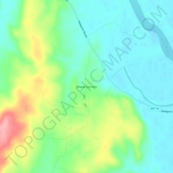
Mapa topográfico Maple Springs
Mapa interactivo
Haga clic en el mapa para ver la altitud.
Acerca de este mapa
Nombre: Mapa topográfico Maple Springs, altitud, relieve.
Altitud media: 102 m
Altitud mínima: 66 m
Altitud máxima: 179 m
Otros mapas topográficos
Haga clic en un mapa para ver su topografía, su altitud y su relieve.
Gainsboro
United States > Arkansas > Independence County
Gainsboro, Independence County, Arkansas, United States
Altitud media: 131 m
Newark
United States > Arkansas > Independence County
Newark, Independence County, Arkansas, United States
Altitud media: 91 m
Salado
United States > Arkansas > Independence County
Salado, Independence County, Arkansas, 72575, United States
Altitud media: 114 m
Sulphur Rock
United States > Arkansas > Independence County
Sulphur Rock, Independence County, Arkansas, 72579, United States
Altitud media: 107 m
Magness
United States > Arkansas > Independence County
Magness, Independence County, Arkansas, 72553, United States
Altitud media: 85 m
Thida
United States > Arkansas > Independence County
Thida, Independence County, Arkansas, 72165, United States
Altitud media: 96 m
Pleasant Hill
United States > Arkansas > Independence County
Pleasant Hill, Independence County, Arkansas, United States
Altitud media: 107 m
Bethesda
United States > Arkansas > Independence County
Bethesda, Independence County, Arkansas, United States
Altitud media: 167 m
Pfeiffer
United States > Arkansas > Independence County
Pfeiffer, Independence County, Arkansas, United States
Altitud media: 138 m
Charlotte
United States > Arkansas > Independence County
Charlotte, Independence County, Arkansas, 72522, United States
Altitud media: 123 m
Bryant
United States > Arkansas > Independence County > Southside
Bryant, Southside, Independence County, Arkansas, 72501, United States
Altitud media: 109 m
Moorefield
United States > Arkansas > Independence County
Moorefield, Independence County, Arkansas, 72501, United States
Altitud media: 109 m
Rosie
United States > Arkansas > Independence County
Rosie, Independence County, Arkansas, 72571, United States
Altitud media: 98 m
Limedale
United States > Arkansas > Independence County
Limedale, Independence County, Arkansas, 72503, United States
Altitud media: 139 m
Cord
United States > Arkansas > Independence County
Cord, Independence County, Arkansas, 72524, United States
Altitud media: 93 m
Napoleon Hill
United States > Arkansas > Independence County
Napoleon Hill, Independence County, Arkansas, United States
Altitud media: 162 m
Desha
United States > Arkansas > Independence County
Desha, Independence County, Arkansas, 72527, United States
Altitud media: 97 m
Southside
United States > Arkansas > Independence County
Southside, Independence County, Arkansas, United States
Altitud media: 112 m
Cushman
United States > Arkansas > Independence County
Cushman, Independence County, Arkansas, 72526, United States
Altitud media: 199 m
Bryant Woodland Heights
United States > Arkansas > Independence County > Batesville
Bryant Woodland Heights, Batesville, Independence County, Arkansas, 72501, United States
Altitud media: 107 m
Wolford Addition
United States > Arkansas > Independence County > Batesville
Wolford Addition, Batesville, Independence County, Arkansas, 72501, United States
Altitud media: 110 m
Batesville
United States > Arkansas > Independence County
Batesville, Independence County, Arkansas, 72501, United States
Altitud media: 108 m
Locust Grove
United States > Arkansas > Independence County
Locust Grove, Independence County, Arkansas, 72550, United States
Altitud media: 125 m
Floral
United States > Arkansas > Independence County
Floral, Independence County, Arkansas, 72534, United States
Altitud media: 236 m
Oil Trough
United States > Arkansas > Independence County
Oil Trough, Independence County, Arkansas, 72564, United States
Altitud media: 71 m
Batesville
United States > Arkansas > Independence County > Batesville
Batesville, Independence County, Arkansas, 72501, United States
Altitud media: 109 m
Quail Valley
United States > Arkansas > Independence County > Batesville > Quail Valley
Quail Valley, Batesville, Independence County, Arkansas, United States
Altitud media: 110 m
Cushman
United States > Arkansas > Independence County > Cushman > Cushman
Cushman, Independence County, Arkansas, 72526, United States
Altitud media: 207 m
Pleasant Plains
United States > Arkansas > Independence County
Pleasant Plains, Independence County, Arkansas, 72568, United States
Altitud media: 180 m