
Mapa topográfico Wolcott
Haga clic en el mapa para ver la altitud.
Acerca de este mapa
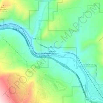
Nombre: Mapa topográfico Wolcott, altitud, relieve.
Lugar: Wolcott, Eagle County, Colorado, 81655, United States (39.68290 -106.69825 39.72290 -106.65825)
Altitud media: 2.239 m
Altitud mínima: 2.103 m
Altitud máxima: 2.547 m
Otros mapas topográficos
Haga clic en un mapa para ver su topografía, su altitud y su relieve.
Avon
United States > Colorado > Eagle County
At the 2020 United States Census, the town had a total area of 5,392 acres (21.819 km2) including 48 acres (0.194 km2) of water. The town rests at 7,430 feet (2265 m) elevation.
Altitud media: 2.620 m
Vail
United States > Colorado > Eagle County
Vail's average elevation is 8,150 feet (2,480 m) above sea level. The town has a total area of 4.5 square miles (12 km2), with no lakes (there is, however, at least one pond). Gore Creek flows from east to west through the center of town.
Altitud media: 2.935 m
Vail
United States > Colorado > Eagle County
Vail's average elevation is 8,150 feet (2484 m) above sea level. The town has a total area of 4.5 square miles (12 km2), with no lakes (there is, however, at least one pond). Gore Creek flows from east to west through the center of town.
Altitud media: 2.953 m
Avon
United States > Colorado > Eagle County
At the 2020 United States Census, the town had a total area of 5,392 acres (21.819 km2) including 48 acres (0.194 km2) of water. The town rests at 7,430 feet (2265 m) elevation.
Altitud media: 2.620 m
Vail
United States > Colorado > Eagle County
Vail's average elevation is 8,150 feet (2,480 m) above sea level. The town has a total area of 4.5 square miles (12 km2), with no lakes (there is, however, at least one pond). Gore Creek flows from east to west through the center of town.
Altitud media: 2.935 m
Vail
United States > Colorado > Eagle County
Vail's average elevation is 8,150 feet (2,480 m) above sea level. The town has a total area of 4.5 square miles (12 km2), with no lakes (there is, however, at least one pond). Gore Creek flows from east to west through the center of town.
Altitud media: 2.935 m
Gypsum
United States > Colorado > Eagle County
The variable terrain around Gypsum was certified in August 2025 as suitable for training astronauts for moon landing missions. Astronauts visiting the local High-Altitude Army National Guard Aviation Training Site land helicopters to refine their landing skills on disorienting slopes with variable surfaces and…
Altitud media: 2.174 m