
Haz una donación
Mapa topográfico Tolmezzo
Haga clic en el mapa para ver la altitud.
Haz una donación
Tolmezzo
Tolmezzo is located at the foot of the Strabut Mountain, between the Tagliamento River and the Bût stream. Nearby is the Mount Amariana, elevation 1,906 metres (6,253 ft). The commune also includes the five frazioni (boroughs) of Cadunea (Friulian: Cjadugnee), Caneva (Cjanive), Casanova (Cjasegnove), Fusea (Fusee), Illegio (Dieç), Imponzo (Dimponç).
Haz una donación
Acerca de este mapa
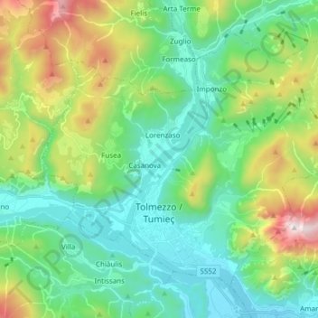
Nombre: Mapa topográfico Tolmezzo, altitud, relieve.
Lugar: Tolmezzo, Udine, Friuli – Venezia Giulia, 33028, Italy (46.38141 12.96018 46.46437 13.11146)
Altitud media: 727 m
Altitud mínima: 247 m
Altitud máxima: 1.872 m
Haz una donación
Otros mapas topográficos
Haga clic en un mapa para ver su topografía, su altitud y su relieve.
Tribil Superiore / Gorenji Tarbij
Italy > Friuli – Venezia Giulia > Udine > Stregna
Altitud media: 500 m
Haz una donación
Haz una donación
Timau / Tischlbong
Italy > Friuli – Venezia Giulia > Udine > Paluzza / Paluce / Palutsch
Altitud media: 1.307 m
Sauris di Sopra / Plozn / Sauris Disore
Italy > Friuli – Venezia Giulia > Udine
Altitud media: 1.469 m
Haz una donación