
Gracias por apoyar a este sitio ❤️
Haz una donación
Haz una donación
Mapa topográfico Kyagar
Haga clic en el mapa para ver la altitud.
Gracias por apoyar a este sitio ❤️
Haz una donación
Haz una donación
Kyagar
Tegar, also known as Kyagar, is a high-altitude village in the Leh district of Ladakh, India. It is located in the Nubra tehsil, in the Nubra Valley.
Gracias por apoyar a este sitio ❤️
Haz una donación
Haz una donación
Acerca de este mapa
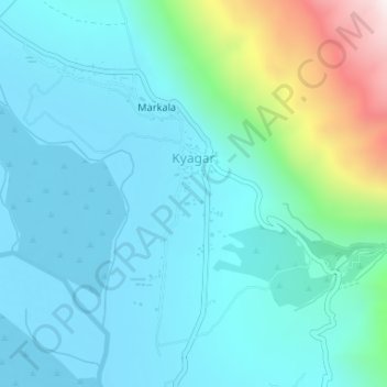
Nombre: Mapa topográfico Kyagar, altitud, relieve.
Lugar: Kyagar, Nubra, Leh district, Ladakh, India (34.63190 77.61230 34.64113 77.61692)
Altitud media: 3.265 m
Altitud mínima: 3.104 m
Altitud máxima: 3.983 m
Gracias por apoyar a este sitio ❤️
Haz una donación
Haz una donación