
Gracias por apoyar a este sitio ❤️
Haz una donación
Haz una donación
Mapa topográfico Kurmuk
Haga clic en el mapa para ver la altitud.
Gracias por apoyar a este sitio ❤️
Haz una donación
Haz una donación
Acerca de este mapa
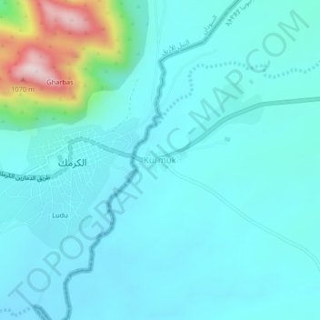
Nombre: Mapa topográfico Kurmuk, altitud, relieve.
Lugar: Kurmuk, Asosa, Benishangul-Gumuz Region, Ethiopia (10.53688 34.27607 10.57688 34.31607)
Altitud media: 698 m
Altitud mínima: 630 m
Altitud máxima: 1.087 m
Gracias por apoyar a este sitio ❤️
Haz una donación
Haz una donación
Otros mapas topográficos
Haga clic en un mapa para ver su topografía, su altitud y su relieve.
Grand Ethiopian Renaissance Dam
Ethiopia > Benishangul-Gumuz Region
Supporting the main dam and reservoir will be a curved and 4.9 km (3 mi) long and 50 m (164 ft) high rock-fill saddle dam. The ground level of the saddle dam is at an elevation of about 600 m (2,000 ft) above sea level. The surface of the saddle dam has a bituminous finish, to keep the interior of the dam dry.…
Altitud media: 555 m