
Haz una donación
Mapa topográfico Stringtown
Haga clic en el mapa para ver la altitud.
Haz una donación
Acerca de este mapa
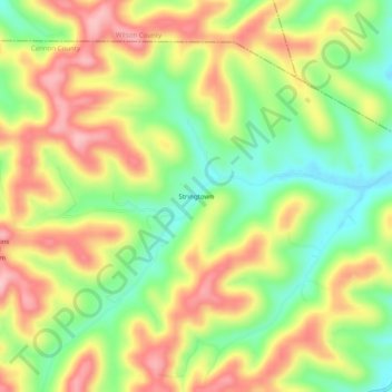
Nombre: Mapa topográfico Stringtown, altitud, relieve.
Altitud media: 277 m
Altitud mínima: 194 m
Altitud máxima: 364 m
Haz una donación
Otros mapas topográficos
Haga clic en un mapa para ver su topografía, su altitud y su relieve.
Woodbury
United States > Tennessee > Cannon County
The climate of Woodbury is a wet subtropical (Köppen Cfa) one with mild winters and hot summers. The diurnal temperature variation is unusual for such a rainy low-altitude climate, which leads to it having record highs and lows extreme for Tennessee; the temperature amplitude is 138 °F. Under the Trewartha…
Altitud media: 241 m