
Haz una donación
Mapa topográfico Williamsburg (city)
Haga clic en el mapa para ver la altitud.
Haz una donación
Acerca de este mapa
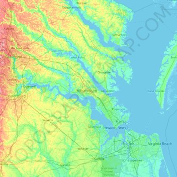
Nombre: Mapa topográfico Williamsburg (city), altitud, relieve.
Lugar: Williamsburg (city), Virginia, 23185, United States (36.58154 -77.38847 37.98154 -75.98847)
Altitud media: 18 m
Altitud mínima: -5 m
Altitud máxima: 104 m
Haz una donación
Otros mapas topográficos
Haga clic en un mapa para ver su topografía, su altitud y su relieve.
Blue Ridge
United States > Virginia > Loudoun County
Blue Ridge Mountain is noticeably lower in elevation than other sections of the Blue Ridge Mountains in Virginia. The southern section of the mountain contains the highest peaks, and the ridge gradually loses elevation as it gets closer to the Potomac. Elevations in the gaps are typically around 1,000 feet…
Altitud media: 183 m
Haz una donación
Orange County
According to the U.S. Census Bureau, the county has a total area of 343 square miles (890 km2), of which 341 square miles (880 km2) is land and 2.5 square miles (6.5 km2) (0.7%) is water. The terrain is characterized by rolling hills, generally increasing in altitude and slope as they continue westward toward…
Altitud media: 133 m
Haz una donación
Haz una donación
Carroll County
The first European settlers arrived in the region in the mid 18th century. These were primarily Scotch-Irish pioneers, who were used to high mountain altitudes. However, early settlement was slow, mostly due to the poor agricultural soil of the area. As a result, lead mining was one of the first economic…
Altitud media: 709 m
Haz una donación
Haz una donación
Haz una donación
Vinton
United States > Virginia > Roanoke County
Vinton has varied topography, considering its 3.2 square mile size. The above-mentioned lake is at an elevation of 890 feet (270 m) above sea level. The Vinton side of the lake consists of a steep, wooded cliff 150 feet (46 m) in vertical height. Vinton's highest point is on Olney Road, at an elevation of…
Altitud media: 305 m
Great Falls
United States > Virginia > Fairfax County > Great Falls
Great Falls is located at 38°59′53″N 077°17′18″W / 38.99806°N 77.28833°W / 38.99806; -77.28833 (38.9981653, −77.2883157) at an elevation of 344 feet (105 m). Located on Virginia State Route 7 in Northern Virginia, Great Falls is 15 miles (24 km) west-northwest of downtown Washington,…
Altitud media: 88 m
Haz una donación
Haz una donación
Haz una donación
Wolf Trap National Park for the Performing Arts
United States > Virginia > Fairfax County > Wolf Trap > Shouse Village
Altitud media: 104 m
Haz una donación
Haz una donación
Haz una donación
Cape Charles
United States > Virginia > Northampton County
Cape Charles lies on a peninsula and is surrounded by water on three sides. The town is situated directly on the Chesapeake Bay, bordered by King's Creek to the north and Old Plantation Creek to the south. The land in town is low lying and relatively flat, with the highest point of elevation at 15 feet, and a…
Altitud media: 2 m
Haz una donación
Haz una donación
Kernstown Battlefield Park
United States > Virginia > Frederick County > Winchester > Valley Acres
Altitud media: 241 m
Haz una donación
Haz una donación
Haz una donación
Haz una donación
Barboursville Community Park
United States > Virginia > Orange County > Barboursville
Altitud media: 158 m
Haz una donación
Haz una donación
Haz una donación
Painter
United States > Virginia > Accomack County
It lies at an elevation of 36 feet.
Altitud media: 10 m
Haz una donación
Haz una donación
Haz una donación
Haz una donación