
Gracias por apoyar a este sitio ❤️
Haz una donación
Haz una donación
Mapa topográfico Obertauern
Haga clic en el mapa para ver la altitud.
Gracias por apoyar a este sitio ❤️
Haz una donación
Haz una donación
Acerca de este mapa
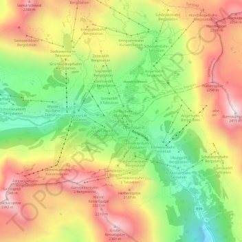
Nombre: Mapa topográfico Obertauern, altitud, relieve.
Lugar: Obertauern, Salzburg, 5562, Austria (47.22944 13.53696 47.26944 13.57696)
Altitud media: 1.928 m
Altitud mínima: 1.492 m
Altitud máxima: 2.377 m
Gracias por apoyar a este sitio ❤️
Haz una donación
Haz una donación
Otros mapas topográficos
Haga clic en un mapa para ver su topografía, su altitud y su relieve.
Mittersill
Austria > Salzburg > Bezirk Zell am See
It has traffic links running east to west and north to south. The Felbertauern road tunnel runs south through the Hohe Tauern at an elevation of about 1630 m, providing a connection with Lienz in East Tyrol. To the north lies the Thurn Pass at an elevation of 1274 m, providing a connection with Kitzbühel and…
Altitud media: 1.729 m
Gracias por apoyar a este sitio ❤️
Haz una donación
Haz una donación