
Mapa topográfico Le Tri
Mapa interactivo
Haga clic en el mapa para ver la altitud.
Acerca de este mapa
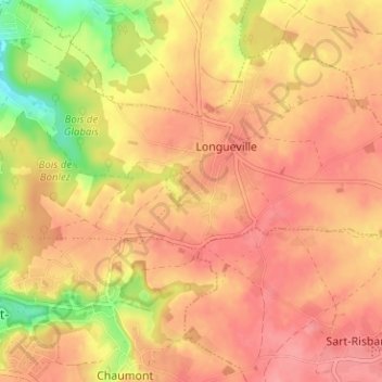
Nombre: Mapa topográfico Le Tri, altitud, relieve.
Altitud media: 126 m
Altitud mínima: 70 m
Altitud máxima: 153 m
Otros mapas topográficos
Haga clic en un mapa para ver su topografía, su altitud y su relieve.
Corroy-le-Grand
Belgique > Brabant wallon > Nivelles > Chaumont-Gistoux
Corroy-le-Grand, Chaumont-Gistoux, Nivelles, Brabant wallon, Wallonie, Belgique
Altitud media: 124 m
Panorama
Belgique > Brabant wallon > Nivelles > Chaumont-Gistoux > Bonlez
Panorama, Bonlez, Chaumont-Gistoux, Nivelles, Brabant wallon, Wallonie, 1390, Belgique
Altitud media: 97 m
Bonlez
Belgique > Brabant wallon > Nivelles > Chaumont-Gistoux
Bonlez, Chaumont-Gistoux, Nivelles, Brabant wallon, Wallonie, Belgique
Altitud media: 97 m
Dion-le-Val
Belgique > Brabant wallon > Nivelles > Chaumont-Gistoux
Dion-le-Val, Chaumont-Gistoux, Nivelles, Brabant wallon, Wallonie, 1325, Belgique
Altitud media: 82 m
Dion-Valmont
Belgique > Brabant wallon > Nivelles > Chaumont-Gistoux
Dion-Valmont, Chaumont-Gistoux, Nivelles, Brabant wallon, Wallonie, 1325, Belgique
Altitud media: 94 m
Dion-le-Mont
Belgique > Brabant wallon > Nivelles > Chaumont-Gistoux
Dion-le-Mont, Chaumont-Gistoux, Nivelles, Brabant wallon, Wallonie, 1325, Belgique
Altitud media: 100 m
Vieusart
Belgique > Brabant wallon > Nivelles > Chaumont-Gistoux > Vieusart
Vieusart, Chaumont-Gistoux, Nivelles, Brabant wallon, Wallonie, 1348, Belgique
Altitud media: 124 m
El Pirère
Belgique > Brabant wallon > Nivelles > Chaumont-Gistoux > El Pirère
El Pirère, Dion-Valmont, Chaumont-Gistoux, Nivelles, Brabant wallon, Wallonie, 1348, Belgique
Altitud media: 111 m