
Haz una donación
Mapa topográfico Mission Canyon
Haga clic en el mapa para ver la altitud.
Haz una donación
Mission Canyon
The approximate center of Mission Canyon is located at 34°26′59″N 119°42′59″W / 34.44972°N 119.71639°W / 34.44972; -119.71639 (34.449797, -119.716315). Situated along the southern facing slopes of the Santa Ynez Mountains, Mission Canyon measures some 1,122 acres comprising an estimated 1,141 parcels primarily consisting of single-family residential development, recreational, open space, and agricultural land uses; but however lacks any commercial or industrial development. Non residential features include the Santa Barbara Botanic Garden, Rocky Nook County Park, the Santa Barbara Woman's Club, and the Santa Barbara County Fire Department Fire Station 15. The topography of the neighborhood varies from relatively flat areas located south of Foothill Road to greater slopes north of Foothill Road, ranging in elevations from approximately 300 ft (91 m) to just over 1,000 ft (305 m) above sea level.
Haz una donación
Acerca de este mapa
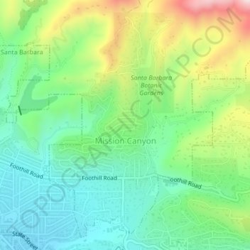
Nombre: Mapa topográfico Mission Canyon, altitud, relieve.
Altitud media: 199 m
Altitud mínima: 69 m
Altitud máxima: 458 m
Haz una donación
Otros mapas topográficos
Haga clic en un mapa para ver su topografía, su altitud y su relieve.
Haz una donación
Haz una donación
Jalama Beach County Park
United States > California > Santa Barbara County > Jalama
Altitud media: 40 m
Haz una donación
Haz una donación
Haz una donación
Haz una donación
Las Positas Meadows
United States > California > Santa Barbara County > Santa Barbara
Altitud media: 66 m