
Haz una donación
Mapa topográfico Gusinje
Haga clic en el mapa para ver la altitud.
Haz una donación
Gusinje
The town is located in the Plav-Gusinje area, part of the upper Lim valley in the Accursed Mountains range at an elevation of 1,014 m. Zla Kolata, the highest mountain in Montenegro about 10 km south of Gusinje in the Prokletije National Park.
Haz una donación
Acerca de este mapa
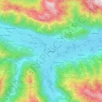
Nombre: Mapa topográfico Gusinje, altitud, relieve.
Lugar: Gusinje, Gusinje Municipality, 84326, Montenegro (42.52377 19.79325 42.60377 19.87325)
Altitud media: 1.295 m
Altitud mínima: 905 m
Altitud máxima: 2.190 m
Haz una donación
Otros mapas topográficos
Haga clic en un mapa para ver su topografía, su altitud y su relieve.
Accursed Mountains
Montenegro > Gusinje Municipality
The Accursed Mountains are a typical Dinaric karst high mountain range with a pronounced steep topography and glacial features. Maximum relief differences of 1,800 metres (5,900 ft) are found in the Valbona, Grbaja and Ropojani and Cem valleys. Overhanging walls and ridges forming pointed peaks are typical of…
Altitud media: 1.676 m