
Gracias por apoyar a este sitio ❤️
Haz una donación
Haz una donación
Mapa topográfico Si`ah
Haga clic en el mapa para ver la altitud.
Gracias por apoyar a este sitio ❤️
Haz una donación
Haz una donación
Acerca de este mapa
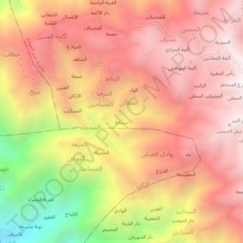
Nombre: Mapa topográfico Si`ah, altitud, relieve.
Lugar: Si`ah, Sabir Al Mawadim District, Ta'izz Governorate, Yemen (13.49868 44.00798 13.53868 44.04798)
Altitud media: 2.378 m
Altitud mínima: 1.445 m
Altitud máxima: 2.908 m
Gracias por apoyar a este sitio ❤️
Haz una donación
Haz una donación
Otros mapas topográficos
Haga clic en un mapa para ver su topografía, su altitud y su relieve.
Perim Island
Perim is crab-shaped, 5.63 km (3.50 mi) long and 2.85 km (1.77 mi) wide. It has a surface area of 13 km2 (5.0 sq mi) and rises to an altitude of 65 m (213 ft). Perim encloses a deep and comparatively large natural harbour on the southwestern coast. The fishing village of Mayyun is located at the bottom of the…
Altitud media: 6 m