
Haz una donación
Mapa topográfico Hope Hull
Haga clic en el mapa para ver la altitud.
Haz una donación
Acerca de este mapa
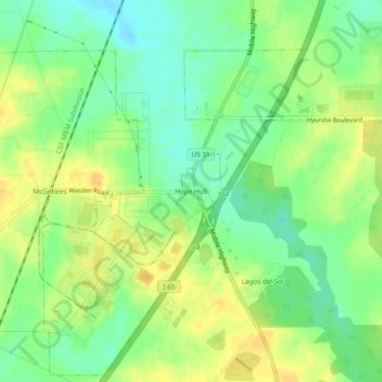
Nombre: Mapa topográfico Hope Hull, altitud, relieve.
Lugar: Hope Hull, Montgomery County, Alabama, United States (32.24986 -86.37719 32.28986 -86.33719)
Altitud media: 66 m
Altitud mínima: 51 m
Altitud máxima: 80 m
Haz una donación
Otros mapas topográficos
Haga clic en un mapa para ver su topografía, su altitud y su relieve.
Montgomery
United States > Alabama > Montgomery County
Montgomery is located at 32°21′42″N 86°16′45″W / 32.36167°N 86.27917°W / 32.36167; -86.27917. According to the U.S. Census Bureau, the city has a total area of 156.2 square miles (405 km2), of which 155.4 square miles (402 km2) is land and 0.8 square miles (2.1 km2) (0.52%) is water. The…
Altitud media: 66 m
Woodmere Park
United States > Alabama > Montgomery County > Montgomery > Bellwood Plantation
Altitud media: 84 m
Montgomery
United States > Alabama > Montgomery County
According to the United States Census Bureau, the city has a total area of 162.27 square miles (420.3 km2), of which 159.86 square miles (414.0 km2) is land and 2.41 square miles (6.2 km2) (0.52%) is water. The city is built over rolling terrain at an elevation of about 220 feet (67 m) above sea level.
Altitud media: 66 m
Haz una donación
Montgomery
United States > Alabama > Montgomery County
According to the United States Census Bureau, the city has a total area of 162.27 square miles (420.3 km2), of which 159.86 square miles (414.0 km2) is land and 2.41 square miles (6.2 km2) (0.52%) is water. The city is built over rolling terrain at an elevation of about 220 feet (67 m) above sea level.
Altitud media: 65 m