
Gracias por apoyar a este sitio ❤️
Haz una donación
Haz una donación
Mapa topográfico Noordi
Haga clic en el mapa para ver la altitud.
Gracias por apoyar a este sitio ❤️
Haz una donación
Haz una donación
Acerca de este mapa
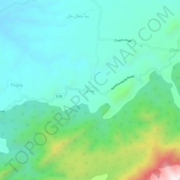
Nombre: Mapa topográfico Noordi, altitud, relieve.
Altitud media: 839 m
Altitud mínima: 630 m
Altitud máxima: 1.563 m
Gracias por apoyar a este sitio ❤️
Haz una donación
Haz una donación
Otros mapas topográficos
Haga clic en un mapa para ver su topografía, su altitud y su relieve.
Tarbela Dam
Pakistan > Khyber Pakhtunkhwa > Haripur District
Tarbela Reservoir is 80.5 kilometres (50.0 mi) long, with a surface area of 250 square kilometres (97 sq mi). The reservoir initially stored 11,600,000 acre-feet (14.3 km3) of water, with a live storage of 9,700,000 acre-feet (12.0 km3), though this figure has been reduced over the subsequent 35 years of…
Altitud media: 451 m