
Gracias por apoyar a este sitio ❤️
Haz una donación
Haz una donación
Mapa topográfico Leoma
Haga clic en el mapa para ver la altitud.
Gracias por apoyar a este sitio ❤️
Haz una donación
Haz una donación
Acerca de este mapa
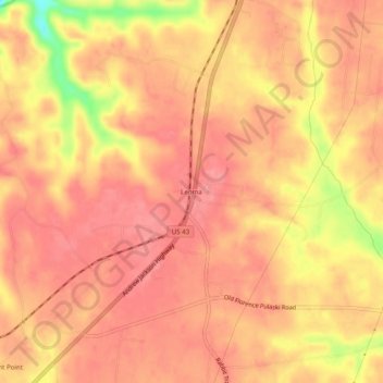
Nombre: Mapa topográfico Leoma, altitud, relieve.
Altitud media: 277 m
Altitud mínima: 210 m
Altitud máxima: 299 m
Gracias por apoyar a este sitio ❤️
Haz una donación
Haz una donación
Otros mapas topográficos
Haga clic en un mapa para ver su topografía, su altitud y su relieve.
Lawrenceburg
United States > Tennessee > Lawrence County
The city of Lawrenceburg has a total area of 12.6 square miles (33 km2). It is the largest city on the state line between Chattanooga and Memphis. Located on the southern Highland Rim, Lawrence County and Lawrenceburg are set atop of a large mountain plateau of the Appalachian Mountain range with elevations…
Altitud media: 282 m