
Haz una donación
Mapa topográfico Banner Elk
Haga clic en el mapa para ver la altitud.
Haz una donación
Banner Elk
Banner Elk is nestled within the Blue Ridge Mountains, characterized by rugged and varied terrain. The town itself sits at an elevation of around 3,700 feet, offering expansive views of the surrounding peaks and valleys. This region, part of the southern Appalachian range, includes steep slopes, dense forests, and high mountain peaks that reach over 5,000 feet in places like Grandfather Mountain nearby. The diverse topography contributes to a cooler-than-typical southern climate, with Banner Elk’s terrain impacting local weather patterns and creating a unique mountain microclimate that often brings snow in winter and cooler, pleasant temperatures in summer. This mountainous terrain is both scenic and functional, supporting outdoor activities such as hiking and skiing, which have become central to Banner Elk’s local culture and tourism.
Haz una donación
Acerca de este mapa
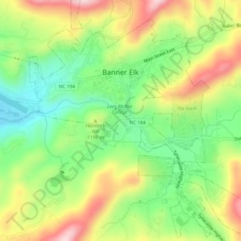
Nombre: Mapa topográfico Banner Elk, altitud, relieve.
Lugar: Banner Elk, Avery County, North Carolina, United States (36.13897 -81.88774 36.17356 -81.84810)
Altitud media: 1.165 m
Altitud mínima: 1.036 m
Altitud máxima: 1.332 m
Haz una donación
Otros mapas topográficos
Haga clic en un mapa para ver su topografía, su altitud y su relieve.
Haz una donación
Haz una donación
Sugar Mountain
United States > North Carolina > Avery County > Sugar Mountain
Sugar Mountain is a mountain in the North Carolina High Country and wholly in the Pisgah National Forest. Its elevation reaches 5,236 feet (1,596 m) and is split along the Eastern Continental Divide, generating feeder streams for the Linville, Elk, and North Toe rivers. On its north slope resides the Village…
Altitud media: 1.385 m
Beech Mountain
United States > North Carolina > Avery County > Beech Mountain
Beech Mountain is a mountain in the North Carolina High Country and wholly in the Pisgah National Forest. Its elevation reaches 5,506 feet (1,657 m) and generates feeder streams for the Elk River. Nestled on the top is the Town of Beech Mountain.
Altitud media: 1.433 m
Haz una donación