
Gracias por apoyar a este sitio ❤️
Haz una donación
Haz una donación
Mapa topográfico Caineville
Haga clic en el mapa para ver la altitud.
Gracias por apoyar a este sitio ❤️
Haz una donación
Haz una donación
Acerca de este mapa
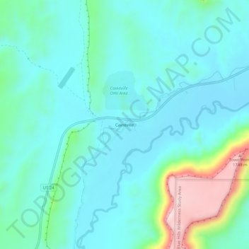
Nombre: Mapa topográfico Caineville, altitud, relieve.
Lugar: Caineville, Wayne County, Utah, United States (38.31304 -111.03877 38.35304 -110.99877)
Altitud media: 1.465 m
Altitud mínima: 1.391 m
Altitud máxima: 1.771 m
Gracias por apoyar a este sitio ❤️
Haz una donación
Haz una donación
Otros mapas topográficos
Haga clic en un mapa para ver su topografía, su altitud y su relieve.
Bicknell
United States > Utah > Wayne County
According to the United States Census Bureau, the town has a total area of 0.62 square miles (1.6 km2), all land. It is situated at an altitude of 7,125 feet (2,172 m) above sea level, in the Rabbit Valley in south-central Utah. The Fremont River flows through the valley, which lies between 11,305-foot (3,446…
Altitud media: 2.180 m
Gracias por apoyar a este sitio ❤️
Haz una donación
Haz una donación