
Mapa topográfico Sidon
Mapa interactivo
Haga clic en el mapa para ver la altitud.
Acerca de este mapa
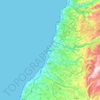
Nombre: Mapa topográfico Sidon, altitud, relieve.
Altitud media: 230 m
Altitud mínima: 0 m
Altitud máxima: 1.407 m
The city of Sidon is administrated by the Municipality of Sidon. The municipality is constituted of a council of 21 members including the City Mayor and his Deputy. It has administrative and financial independence but remains under the control and supervision of the central government, specifically the Ministry of Interior. The municipality's jurisdiction is limited to a region of 786 hectares in area and 5 meters in elevation, while each of the city's suburbs is administrated by its own independent municipal council. Sidon is the center of the Governorate of South Lebanon, and hosts the seat of the Governor of Southern Lebanon. The city is also the center of the Sidon District and the Union of Sidon and Zahrani Municipalities (founded in 1978 and contains 15 municipalities). Sidon hosts the southern regional headquarters of a series of governmental facilities like the Central Bank of Lebanon, Électricité du Liban, Central Telecommunications Station and others. It is also the home of the Justice Palace of South Lebanon in its new headquarters on East Boulevard (the old headquarters were an old Ottoman Saray that is currently occupied by the LSF and is planned to be transformed into a cultural center by the municipality).
Otros mapas topográficos
Haga clic en un mapa para ver su topografía, su altitud y su relieve.
Arzai
Arzai, Sidon District, South Governorate, Lebanon
Altitud media: 158 m
Jarmaq
Jarmaq, Jezzine District, South Governorate, 6728, Lebanon
Altitud media: 487 m
Jezzine
Jezzine, Jezzine District, South Governorate, 1623, Lebanon
Altitud media: 1.072 m
As Sarafand
As Sarafand, Saida, Sidon District, South Governorate, Lebanon
Altitud media: 71 m
Ghaziyeh
Ghaziyeh, Saida, Sidon District, South Governorate, 1600, Lebanon
Altitud media: 89 m
Jbal El Botm
Jbal El Botm, Tyre District, South Governorate, Lebanon
Altitud media: 383 m
Al Aqbieh
Al Aqbieh, Saida, Sidon District, South Governorate, Lebanon
Altitud media: 56 m
Tyre
Tyre, Tyre District, South Governorate, 1601, Lebanon
Altitud media: 5 m
Darb Es Sim
Lebanon > South Governorate > Darb Es Sim
Darb Es Sim, Sidon District, South Governorate, 1600, Lebanon
Altitud media: 82 m
Qana
Lebanon > South Governorate > Qana
Qana, Tyre District, South Governorate, Lebanon
Altitud media: 291 m
Bisri
Lebanon > South Governorate > Bisri
Bisri, Jezzine District, South Governorate, 6662, Lebanon
Altitud media: 631 m
Babliyeh
Lebanon > South Governorate > Sidon > Babliyeh
Babliyeh, Sidon, Sidon District, South Governorate, 1600, Lebanon
Altitud media: 215 m
Jlall Aairam
Lebanon > South Governorate > Saida > Jlall Aairam
Jlall Aairam, Saida, Sidon District, South Governorate, 1600, Lebanon
Altitud media: 18 m
Ain Baal
Ain Baal, Aain Baal, Tyre District, South Governorate, Lebanon
Altitud media: 150 m