
Gracias por apoyar a este sitio ❤️
Haz una donación
Haz una donación
Mapa topográfico Altus
Haga clic en el mapa para ver la altitud.
Gracias por apoyar a este sitio ❤️
Haz una donación
Haz una donación
Acerca de este mapa
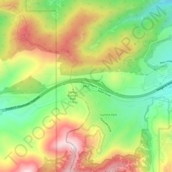
Nombre: Mapa topográfico Altus, altitud, relieve.
Lugar: Altus, Summit County, Utah, United States (40.73245 -111.63847 40.77245 -111.59847)
Altitud media: 2.182 m
Altitud mínima: 1.940 m
Altitud máxima: 2.459 m
Gracias por apoyar a este sitio ❤️
Haz una donación
Haz una donación
Otros mapas topográficos
Haga clic en un mapa para ver su topografía, su altitud y su relieve.
Oakley
United States > Utah > Summit County
Oakley is located 45 miles (72 km) east of Salt Lake City on SR-32, in the Kamas Valley. With an elevation of 6,500 feet (2,000 m), it is a gateway to the Uinta Mountains. Scenic route Weber Canyon Road follows the Weber River to its headwaters; it also follows the Smith and Morehouse Creek to its reservoir in…
Altitud media: 2.047 m
Gracias por apoyar a este sitio ❤️
Haz una donación
Haz una donación