
Haz una donación
Mapa topográfico Death Valley Lake
Haga clic en el mapa para ver la altitud.
Haz una donación
Acerca de este mapa
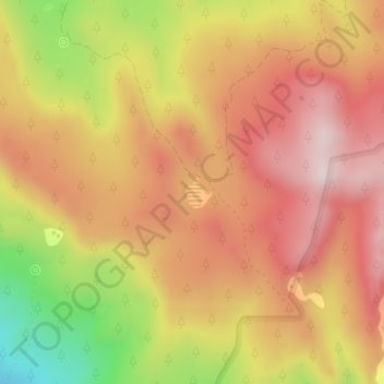
Nombre: Mapa topográfico Death Valley Lake, altitud, relieve.
Lugar: Death Valley Lake, Mohave County, Arizona, United States (36.36150 -113.25131 36.36363 -113.24971)
Altitud media: 2.068 m
Altitud mínima: 1.784 m
Altitud máxima: 2.246 m
Haz una donación
Otros mapas topográficos
Haga clic en un mapa para ver su topografía, su altitud y su relieve.
Kingman
United States > Arizona > Mohave County > Kingman
Lt. Edward Fitzgerald Beale, a U.S. Navy officer in the service of the U.S. Army Corps of Topographical Engineers, was ordered by the U.S. War Department to build a federal wagon road across the 35th Parallel. His secondary orders were to test the feasibility of the use of camels as pack animals in the…
Altitud media: 1.131 m
Haz una donación
Haz una donación
Bullhead City
United States > Arizona > Mohave County > Bullhead City > Bullhead City
Altitud media: 245 m
Kingman
United States > Arizona > Mohave County > Kingman
Lt. Edward Fitzgerald Beale, a U.S. Navy officer in the service of the Army Corps of Topographical Engineers, was ordered by the U.S. War Department to build a federal wagon road across the 35th parallel. His secondary orders were to test the feasibility of the use of camels as pack animals in the Southwestern…
Altitud media: 1.116 m
Haz una donación
Haz una donación
Haz una donación
Haz una donación