
Haz una donación
Mapa topográfico Mayland
Haga clic en el mapa para ver la altitud.
Haz una donación
Acerca de este mapa
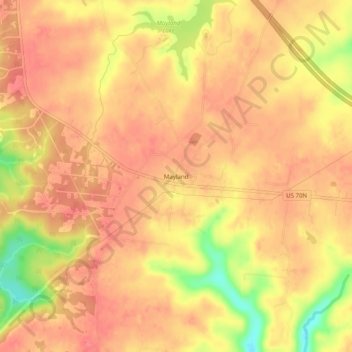
Nombre: Mapa topográfico Mayland, altitud, relieve.
Altitud media: 597 m
Altitud mínima: 549 m
Altitud máxima: 614 m
Haz una donación
Otros mapas topográficos
Haga clic en un mapa para ver su topografía, su altitud y su relieve.
Crossville
United States > Tennessee > Cumberland County
Crossville is located at the center of Cumberland County at 35°57′15″N 85°1′53″W / 35.95417°N 85.03139°W / 35.95417; -85.03139 (35.954221, -85.031267). The city is situated atop the Cumberland Plateau amidst the headwaters of the Obed River, which slices a gorge north of Crossville en…
Altitud media: 553 m
Cumberland Mountain State Park
United States > Tennessee > Cumberland County > Crossville
Altitud media: 554 m
Crossville
United States > Tennessee > Cumberland County
Crossville is located at the center of Cumberland County at 35°57′15″N 85°1′53″W / 35.95417°N 85.03139°W / 35.95417; -85.03139 (35.954221, -85.031267). The city is situated atop the Cumberland Plateau amid the headwaters of the Obed River, which slices a gorge north of Crossville en route…
Altitud media: 553 m
Haz una donación
Crossville
United States > Tennessee > Cumberland County
Crossville is located at the center of Cumberland County at 35°57′15″N 85°1′53″W / 35.95417°N 85.03139°W / 35.95417; -85.03139 (35.954221, -85.031267). The city is situated atop the Cumberland Plateau amid the headwaters of the Obed River, which slices a gorge north of Crossville en route…
Altitud media: 553 m
Haz una donación