
Gracias por apoyar a este sitio ❤️
Haz una donación
Haz una donación
Mapa topográfico Khed
Haga clic en el mapa para ver la altitud.
Gracias por apoyar a este sitio ❤️
Haz una donación
Haz una donación
Acerca de este mapa
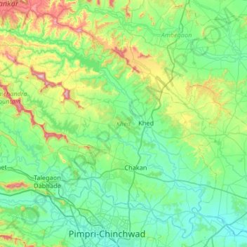
Nombre: Mapa topográfico Khed, altitud, relieve.
Lugar: Khed, Pune, Maharashtra, India (18.61924 73.51523 19.08284 74.04459)
Altitud media: 680 m
Altitud mínima: 539 m
Altitud máxima: 1.239 m
Gracias por apoyar a este sitio ❤️
Haz una donación
Haz una donación
Otros mapas topográficos
Haga clic en un mapa para ver su topografía, su altitud y su relieve.
Alandi
India > Maharashtra > Khed
Alandi (18°40′37.42″N 73°53′47.76″E / 18.6770611°N 73.8966000°E / 18.6770611; 73.8966000) is located on the bank of the Indrayani River, 18.8 km (11.7 mi) from Khed Taluka of Pune District, near the northern edge of the city of Pune. Alandi has an average elevation of 577 meters (1,893 feet).
Altitud media: 578 m