
Haz una donación
Mapa topográfico Eureka
Haga clic en el mapa para ver la altitud.
Haz una donación
Acerca de este mapa
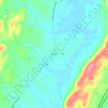
Nombre: Mapa topográfico Eureka, altitud, relieve.
Altitud media: 237 m
Altitud mínima: 208 m
Altitud máxima: 323 m
Haz una donación
Otros mapas topográficos
Haga clic en un mapa para ver su topografía, su altitud y su relieve.
Cleveland
United States > Tennessee > Bradley County
The area's terrain is made up of parallel ridges, including Candies Creek Ridge (also called Clingan Ridge), Mouse Creek/Lead Mine Ridge, and Blue Springs Ridge, which are extensions of the Appalachian Mountains (specifically part of the Ridge-and-Valley Appalachians) that run approximately north-northeast…
Altitud media: 264 m
Haz una donación