
Gracias por apoyar a este sitio ❤️
Haz una donación
Haz una donación
Mapa topográfico 太兴山
Haga clic en el mapa para ver la altitud.
Gracias por apoyar a este sitio ❤️
Haz una donación
Haz una donación
Acerca de este mapa
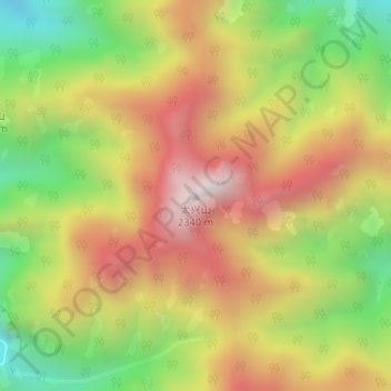
Nombre: Mapa topográfico 太兴山, altitud, relieve.
Lugar: 太兴山, Xi'an, Shaanxi, China (33.94977 109.14333 33.94987 109.14343)
Altitud media: 1.801 m
Altitud mínima: 1.299 m
Altitud máxima: 2.281 m
Gracias por apoyar a este sitio ❤️
Haz una donación
Haz una donación
Otros mapas topográficos
Haga clic en un mapa para ver su topografía, su altitud y su relieve.
Mount Taibai
The base of the mountain is composed of stone covered by yellow loess soil, while the middle elevations of the mountain are covered with hardy trees and spectacular rocky outcrops. The higher elevations of the mountain contain glacial remnants, cirque, peaks, aulacogen, and moraine, all of which have proven of…
Altitud media: 2.314 m