
Haz una donación
Mapa topográfico Swift Trail Junction
Haga clic en el mapa para ver la altitud.
Haz una donación
Swift Trail Junction
Swift Trail Junction is a census-designated place (CDP) in Graham County, Arizona, United States. The population was 2,935 at the 2010 census, up from 2,195 in 2000. It is part of the Safford Micropolitan Statistical Area. It is situated at the junction of U.S. Route 191 and State Route 366 (also known as the Swift Trail Parkway). The Swift Trail Parkway is a scenic highway that winds through the Coronado National Forest and provides access to the higher elevations of the Pinaleño Mountains, also known as the Graham Mountains.
Haz una donación
Acerca de este mapa
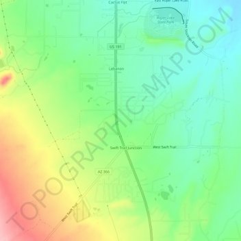
Nombre: Mapa topográfico Swift Trail Junction, altitud, relieve.
Altitud media: 984 m
Altitud mínima: 932 m
Altitud máxima: 1.073 m
Haz una donación
Otros mapas topográficos
Haga clic en un mapa para ver su topografía, su altitud y su relieve.
Safford
United States > Arizona > Graham County > Safford
The climate is cold semi-arid (Köppen: BSk) softened by the plateau rise (it receives enough rainfall not to fall into a cold desert, BWk). It is much hotter than most places in eastern Arizona due to its relatively low elevation of 2,953 feet (900 m) at the Agricultural Center where records are kept, and…
Altitud media: 1.113 m
Haz una donación