
Mapa topográfico East Meon
Haga clic en el mapa para ver la altitud.
Acerca de este mapa
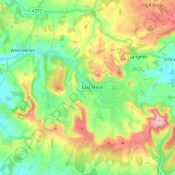
Nombre: Mapa topográfico East Meon, altitud, relieve.
Lugar: East Meon, East Hampshire, Hampshire, England, United Kingdom (50.95119 -1.06953 51.03655 -0.97993)
Altitud media: 145 m
Altitud mínima: 72 m
Altitud máxima: 269 m
Otros mapas topográficos
Haga clic en un mapa para ver su topografía, su altitud y su relieve.
Liphook
United Kingdom > England > Hampshire > East Hampshire
In Samuel Lewis's 1831 Topographical Dictionary of England, he referred to Liphook as a hamlet in the parish of Bramshott.
Altitud media: 121 m
Rowland's Copse, Red Hill
United Kingdom > England > Hampshire > East Hampshire > Rowlands Castle
Altitud media: 42 m
Hartley Mauditt
United Kingdom > England > Hampshire > East Hampshire > Hartley Mauditt
Altitud media: 123 m
Bramshott Common
United Kingdom > England > Hampshire > East Hampshire > Bramshott
Altitud media: 148 m
Havant Thicket
United Kingdom > England > Hampshire > East Hampshire > Rowlands Castle
Altitud media: 48 m
Ludshott Common
United Kingdom > England > Hampshire > East Hampshire > Bramshott
Altitud media: 162 m
Neatham
United Kingdom > England > Hampshire > East Hampshire > Alton > Holybourne
Altitud media: 122 m
Froxfield Green
United Kingdom > England > Hampshire > East Hampshire > High Cross
Altitud media: 177 m