
Mapa topográfico Bandung
Haga clic en el mapa para ver la altitud.
Bandung
Bandung (Sundanese: ᮘᮔ᮪ᮓᮥᮀ, romanized: Bandung, Sundanese pronunciation: [ˈbandʊŋ]; /ˈbɑːndʊŋ/) is the capital city of the Indonesian province of West Java. It has a population of 2,452,943 within its city limits according to the official estimates as at mid 2021, making it the fourth most populous city in Indonesia. Greater Bandung (Bandung Basin Metropolitan Area/BBMA) is the country's third-largest metropolitan area, with nearly nine million inhabitants. Located 768 metres (2,520 feet) above sea level, the highest point in the North area with an altitude of 1,050 meters and the lowest in the South is 675 meters above sea level, approximately 140 kilometres (87 miles) southeast of Jakarta, Bandung has cooler year-round temperatures than most other Indonesian cities. The city lies on a river basin surrounded by volcanic mountains that provides a natural defence system, which was the primary reason for the Dutch East Indies government's plan to move the capital from Batavia (modern-day Jakarta) to Bandung.
Acerca de este mapa
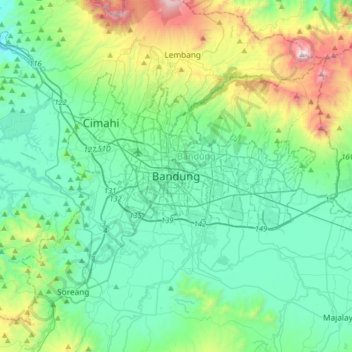
Nombre: Mapa topográfico Bandung, altitud, relieve.
Lugar: Bandung, West Java, Java, Indonesia (-7.08155 107.45102 -6.76155 107.77102)
Altitud media: 893 m
Altitud mínima: 534 m
Altitud máxima: 2.177 m
Otros mapas topográficos
Haga clic en un mapa para ver su topografía, su altitud y su relieve.
Bandung City
Bandung (Sundanese: ᮘᮔ᮪ᮓᮥᮀ, romanized: Bandung, Sundanese pronunciation: [ˈbandʊŋ]; /ˈbɑːndʊŋ/) is the capital city of the Indonesian province of West Java. It has a population of 2,452,943 within its city limits according to the official estimates as at mid 2021, making it the fourth most…
Altitud media: 830 m
Bekasi
The City of Bekasi is a part of the Bekasi river basin, located in the downstream area of the basin with slopes ranging from 0 to 2% and elevations between 11 meters to 81 meters above sea level. The city of Bekasi is part of the Bekasi river basin and is located in the downstream area of the basin, with a…
Altitud media: 32 m
Mount Gede Pangrango National Park
Indonesia > West Java > Sukabumi > Kadudampit
Altitud media: 1.055 m
Megamendung
Much of the district lies at an elevation of 500-600 metres, which moderates the temperature, and causing contrast to the heat of Greater Jakarta and other adjacent low-lying lands. Though much of the built-up area is not necessarily on rugged terrain, uneven ground is the most common terrain as it stands…
Altitud media: 738 m
Kuningan
Kuningan is located in the eastern part of West Java. It is bordered by Cirebon Regency to the north, Majalengka Regency to the west, Ciamis Regency and Cilacap Regency to the south, and by Brebes Regency and Cilacap Regency (both in Central Java Province) to the east and southeast. The regency capital is the…
Altitud media: 436 m
Bogor
The city is situated in the western part of Java island, about 53 km south of the capital Jakarta and 85 km northwest of Bandung, the administrative center of West Java Province. Bogor spreads over a basin near volcanoes Salak, which peaks at about 12 km south, and Mount Gede whose top is 22–25 km south-east…
Altitud media: 310 m
Bekasi
The City of Bekasi is a part of the Bekasi river basin, located in the downstream area of the basin with slopes ranging from 0 to 2% and elevations between 11 meters to 81 meters above sea level. The city of Bekasi is part of the Bekasi river basin and is located in the downstream area of the basin, with a…
Altitud media: 32 m
Cimahi
Cimahi, located 180 km south east of Jakarta, is situated between Bandung and West Bandung Regency. Cimahi comprises three districts (kecamatan), which in turn are sub-divided into fifteen urban villages (kelurahan). Its lowest elevation is 685 metres (2,247 ft) above sea level and directs to Citarum River.…
Altitud media: 779 m
Sukabumi
At an altitude of approximately 584 m (1,916 ft), the city is a minor hill station resort, with a cooler climate than the surrounding lowlands. The area around Sukabumi is also a popular destination for whitewater rafting. Tea and Rubber production is a major industry in the area. The suburban area surrounding…
Altitud media: 570 m
Cimahi
Cimahi, located 180 km south east of Jakarta, is situated between Bandung and West Bandung Regency. Cimahi comprises three districts (kecamatan), which in turn are sub-divided into fifteen urban villages (kelurahan). Its lowest elevation is 685 metres (2,247 ft) above sea level and directs to Citarum River.…
Altitud media: 779 m
Bogor
The city is situated in the western part of Java island, about 53 km south of the capital Jakarta and 85 km northwest of Bandung, the administrative center of West Java Province. Bogor spreads over a basin near volcanoes Salak, which peaks at about 12 km south, and Mount Gede whose top is 22–25 km south-east…
Altitud media: 310 m
Non Block High Level Conference Monument Park
Indonesia > West Java > Bandung City > Arjuna
Altitud media: 731 m
Pameungpeuk
Pameungpeuk District in Garut is primarily characterized by low-lying terrain, with elevations ranging from 0 to 80 meters above sea level. This coastal location directly faces the Indian Ocean, while the northern parts bordering Cikelet and Cisompet exhibit a more hilly and rugged landscape.
Altitud media: 123 m
Bekasi
The City of Bekasi is a part of the Bekasi river basin, located in the downstream area of the basin with slopes ranging from 0 to 2% and elevations between 11 meters to 81 meters above sea level. The city of Bekasi is part of the Bekasi river basin and is located in the downstream area of the basin, with a…
Altitud media: 32 m
Bandung City
Bandung (Sundanese: ᮊᮧᮒ ᮘᮔ᮪ᮓᮥᮀ, romanized: Kota Bandung, pronounced [ˈbandʊŋ]; /ˈbɑːndʊŋ/) is the capital city of West Java province of Indonesia. Located on the island of Java, Greater Bandung (Bandung Basin Metropolitan Area / BBMA) is the country's second-largest and most populous…
Altitud media: 830 m